What is InfraDoctor®?
The system for supporting infrastructure maintenance
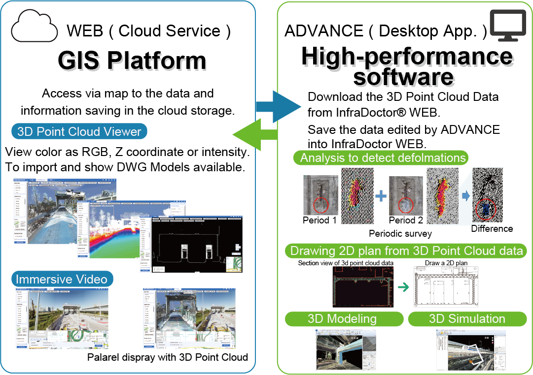
InfraDoctor® is offered as the software service by a cloud GIS platform and desktop application.
This system was deveroped by Aerotoyota Corporation,
Elysium Co. Ltd.,
Shutoko Engineering Company Limited..
The cloud service (InfraDoctor®WEB) based a GIS platform. The system is super efficient, allowing the inspections, maintenance management, road repair and design works to be more precisely targeted.
The desktop application (InfraDoctor®ADVANCE) is a software to edit and analyze 3d point cloud data based InfiPoints® wihch has a competitive advantage in handling large 3d point cloud data.
InfraDoctor®ADVANCE InfraDoctor® is available by downloading from InfraDoctor® WEB.
Patients about InfraDoctor®(Japan)
#6465421、#6503500、#6284240、#6590653
InfraDoctor®WEB (GIS Platform Cloud Service)
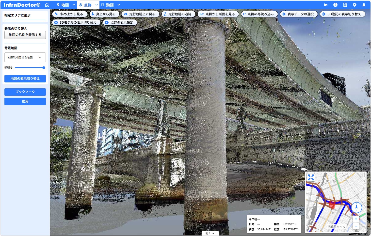
3d point cloud VIWER
You can view point cloud data stored in the cloud storage using a web browser and easily perform tasks such as taking measurements and creating crosssections. Leveraging the strengths of a GIS platform, you can select specific locations directly on a map. This allows you to quickly access the infromation you need and dramatically improve operational efficiency. The system is ideal for road and railway administrators who manage extensive point cloud data, videos, and other materials.
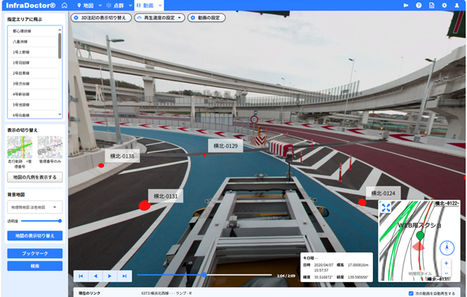
360-degree VIDEO VIWER
You can view 360-degree videos linked to point cloud data and location information directly in a web browser. The videos can be displayed side by side with the point cloud data. Just like with the point cloud data, you can select a location from the map, making the system easy for anyone to use.
Data Management SYSTEM
InfraDoctor®, build on a GIS platform, streamlines data management on onpremises servers.
This solution was developed between NIPPON STEEL TEXENG and Shutoko Engineering.
This helps to solve such as:
Not knowing where acquired point cloud data has been stored
Company policies prohibiting the use of cloud storage
Re-aquiring point cloud data without realizing it had already been collected by another branch, etc...
You can download the leaflet here.(Only Japanese)
InfraDoctor®ADVANCE (Desktop Application)
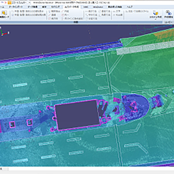
Drawing Support
Drawing 2D plan using point cloud data
You can draw correct polylines on your CAD software with selected point cloud data coordinate data.
You can export a dwg file with a crosssection of point cloud data.
Show Detail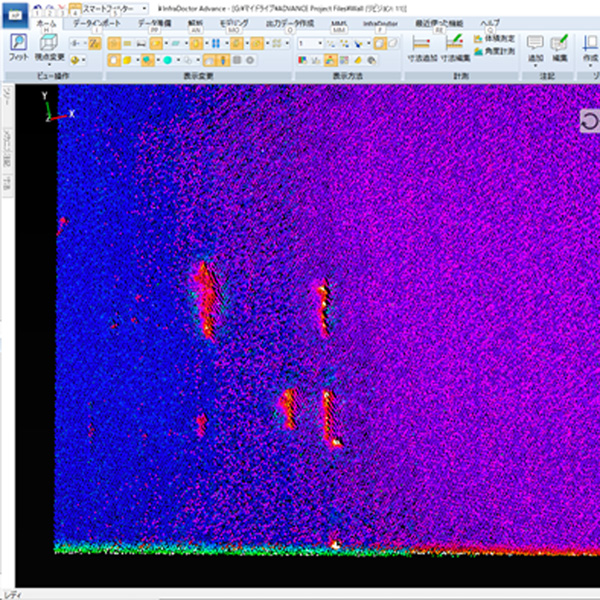
Roughness Analysis
Analyze the condition of the wall, road, etc
You can use the function to expand the point cloud of the tunnel to display the state of the wall as a plane.
In addition to comparing the point cloud at two periods, you can also use the method of indexing the height display and the state of the surface with analysis processing.
Show Detail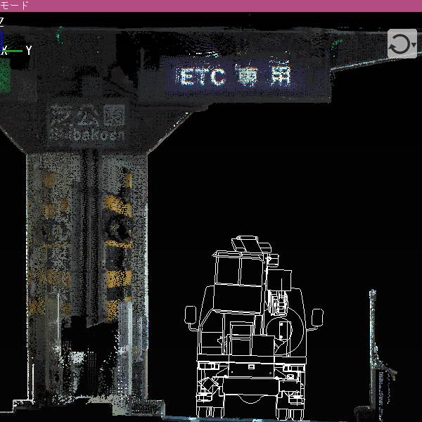
3D Simulation
Checking whether the vehicle used for construction and inspection is suitable for the site
By importing 3D models or real sizing plans into point cloud data, you can verify if objects are free of obstruction in 3D view.
Some 3D models are preset in the ADVANCE application, which you use to simulate in 3D view.
FAQs
Which operating system does InfraDoctor® run on?
InfraDoctor® WEB is supported by Google Chrome, Microsoft Edge on Windows or Mac.
InfraDoctor® ADVANCE can run on Microsoft® 64-bit Windows 10 and 64-bit Windows 11.
Recommended specs are;
Memory: More than 16GB
Disks: More than 20GB free space (We recommend using SSD.)
Graphics card: Open GL support (ex; Quadro, GeForce)
[Verified OpenGL Grafhics card (64bit)]
NVIDIA Quadro K420
NVIDIA GeForce GTX 1060 6GB
NVIDIA Quadro K600
NVIDIA GeForce GTX 1070
NVIDIA Quadro K620
NVIDIA GeForce GTX 1070Ti
NVIDIA Quadro K2000
NVIDIA GeForce RTX 2070 SUPER
NVIDIA Quadro K4000
NVIDIA GeForce RTX 3060
NVIDIA Quadro K6000
NVIDIA GeForce RTX 3080
NVIDIA Quadro P620
Which web browser can I use?
Use the newest Microsoft® Edge or Google Chrome.
How can I see the realistic InfraDoctor®?
The email icon on the upper left on this website provides access to an exhibition and demonstration.